
文件:Locator map of South Korea.svg

呢個「SVG」檔案嘅呢個「PNG」預覽嘅大細:250 × 115 像素。 第啲解像度:320 × 147 像素 | 640 × 294 像素 | 1,024 × 471 像素 | 1,280 × 589 像素 | 2,560 × 1,178 像素。
原本檔案 (SVG檔案,表面大細: 250 × 115 像素,檔案大細:1.18 MB)
摘要
| 描述 |
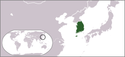
English: Locator map of South Korea. |
| 日期 | |
| 來源 | 自己作品 |
| 作者 | Ksiom |
| Other versions |
  |
協議
| I, the copyright holder of this work, release this work into the public domain. This applies worldwide. In some countries this may not be legally possible; if so: I grant anyone the right to use this work for any purpose, without any conditions, unless such conditions are required by law. |
檔案歷史
撳個日期/時間去睇響嗰個時間出現過嘅檔案。
| 日期/時間 | 縮圖 | 尺寸 | 用戶 | 註解 | |
|---|---|---|---|---|---|
| 現時 | 2009年9月26號 (六) 02:25 | | 250 × 115(1.18 MB) | Ksiom | Reverted to version as of 17:32, 10 July 2009 |
| 2009年9月13號 (日) 03:36 |  | 1,000 × 460(1.45 MB) | Seb az86556 | color-scheme | |
| 2009年7月10號 (五) 17:32 |  | 250 × 115(1.18 MB) | Ksiom | revised version | |
| 2008年10月30號 (四) 13:36 |  | 250 × 115(1.34 MB) | Ksiom | rv (Ulleungdo and Dokdo are too small to be rendered in such a small map) | |
| 2008年10月30號 (四) 12:12 |  | 250 × 115(1.37 MB) | 쿠도군 | ||
| 2008年10月19號 (日) 20:13 |  | 250 × 115(1.34 MB) | Ksiom | ||
| 2008年10月19號 (日) 17:27 |  | 250 × 189(229 KB) | Ksiom | {{Information |Description={{en|1=Locator map of South Korea.}} |Source=Own work by uploader |Author=Ksiom |Date=2008-10-20 |Permission= |other_versions= }} <!--{{ImageUpload|full}}--> |
檔案用途
以下嘅1版用到呢個檔:
全域檔案使用情況
下面嘅維基都用緊呢個檔案:
- ace.wikipedia.org嘅使用情況
- als.wikipedia.org嘅使用情況
- ang.wikipedia.org嘅使用情況
- ar.wikipedia.org嘅使用情況
- ast.wikipedia.org嘅使用情況
- as.wikipedia.org嘅使用情況
- az.wikipedia.org嘅使用情況
- ba.wikipedia.org嘅使用情況
- bg.wikipedia.org嘅使用情況
- blk.wiktionary.org嘅使用情況
- bn.wikipedia.org嘅使用情況
- bo.wikipedia.org嘅使用情況
- bpy.wikipedia.org嘅使用情況
- br.wikipedia.org嘅使用情況
- bs.wikipedia.org嘅使用情況
- ca.wikipedia.org嘅使用情況
- cdo.wikipedia.org嘅使用情況
- chr.wikipedia.org嘅使用情況
- csb.wikipedia.org嘅使用情況
- cy.wikipedia.org嘅使用情況
- de.wikipedia.org嘅使用情況
- de.wiktionary.org嘅使用情況
- dsb.wikipedia.org嘅使用情況
- dv.wikipedia.org嘅使用情況
- dz.wikipedia.org嘅使用情況
- en.wikipedia.org嘅使用情況
- en.wiktionary.org嘅使用情況
- es.wikipedia.org嘅使用情況
睇呢個檔案嘅更多全域使用情況。